MÉTA Program >>> Élőhelyek elterjedési térképei![]()
![]()
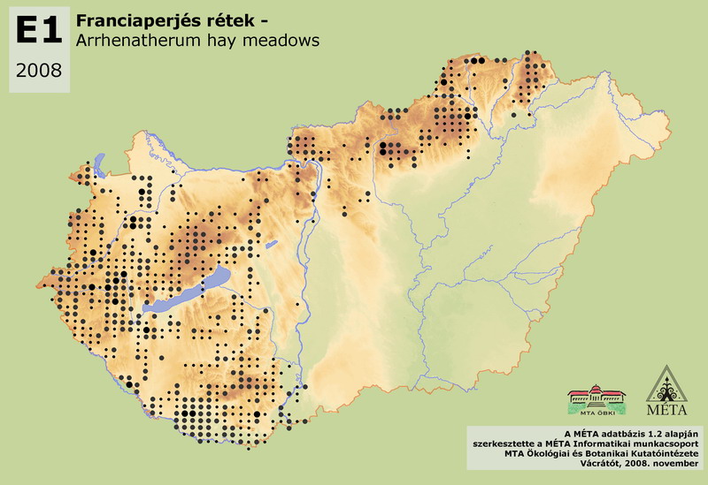
E1 - Franciaperjés rétek:
Domb- és hegyvidéki völgyek, teraszok, medencék, magas árterek tápanyagokban gazdag talajainak mezofil rétjei. Magas füvű uralkodó fajait (franciaperje – Arrhenatherum elatius, csomós ebír – Dactylis glomerata, réti komócsin – Phleum pratense, selyemperje – Holchus lanatus, aranyzab – Trisetum flavescens, réti perje – Poa pratensis) réti virágok sokasága egészíti ki. Jelenlegi összes hazai kiterjedésük mintegy 20000 ha, ennek fele a Dunántúl csapadékosabb, elsősorban dombvidéki részein található (Nyugat-Dunántúl 5300 ha, Dél-Dunántúl 4600 ha). Nagyobb mennyiségben fordul még elő az Északi középhegységben is (4000 ha). Az Alföldön a csapadékosabb területeken, a széleken található (3000 ha), elsősorban a Dráva mentén, ahogy a Kisalföldnek is elsősorban a déli (csapadékosabb) részén fordul elő (1500 ha), de a dunántúli-középhegységi előfordulásának súlypontja is a csapadékosabb részekre esik (1300 ha). Üde erdők szegélyein, tisztásain, egykori irtásain kialakított, korábban kaszálással hasznosított és fenntartott élőhely. A hagyományos réthasználat visszaszorulása az élőhely kiterjedésének csökkenése irányába hat, ugyanakkor a mocsárrétek kiszáradása során részben ez az élőhely alakul ki. Mivel a franciaperjés és a veres csenkeszes rétek [E2] fajai között sok a közös, a két élőhely gyakran egymáshoz igen hasonló lehet. A franciaperjés rétek [E1] felismerését így sok, a jellegtelen gyepek [OB, OC] és a mocsárrétek [D34], illetve egyéb rétek [E2] felé átmeneti állomány nehezítette.
E1 – Arrhenatherum hay meadows:
Mesic meadows of nutrient rich soils developed in areas of colline and submontane valleys, terraces, basins, high floodplains. The dominant tall grass species of the habitat (Arrhenatherum elatius, Dactylis glomerata, Phleum pratense, Holcus lanatus, Trisetum flavescens, Poa pratensis) are completed by a legion of flowering meadow species. The total actual area in Hungary is approximately 20000 ha. The half of it can be found in the humid, mainly hilly part of Dunántúl (Nyugat-Dunántúl 5300 ha, Dunántúli-dombság 4600 ha). It covers also large areas in the Északi-középhegység (4000 ha). The humid parts of Alföld, mainly the edges of that (3000 ha), like areas along Dráva River, offer adequate environment for the habitat. Similarly, these hay meadows occur mainly in the (more humid) southern part of Kisalföld (1500 ha), and in the relatively rainy parts of the Dunántúli-középhegység (1300 ha). In the past, hay meadows were formed at fringes, openings and clearings of mesic forests, and were used and maintained by mowing. The gradual abandonment of the traditional management leads to the reduction of the area of this habitat. On the other hand, partly this habitat develops from drying mesotrophic wet meadows. The identification of Arrhenatherum hay meadows (E1) is difficult towards the transitional stands of uncharacteristic meadows, grasslands and tall herb communities (OB, OC), mesotrophic wet meadows (D34) and other hay meadows (E2).
Molnár, Zs., M. Biró, J. Bölöni & F. Horváth (2008): Distribution of the (semi-)natural habitats in Hungary I.: Marshes and grasslands, Acta Botanica Hungarica 50 (Suppl): 59-105. >>> letöltés (5,4 MB, PDF)
MÉTA Program,
MÉTA Fotótár
MÉTA Élőhely-Ismereti Útmutató (ÉIÚ),
MÉTA Adatlap-Kitöltési Útmutató (AL-KÚ)
(C) MÉTA Informatika, 2005-2009,
MTA Ökológiai és Botanikai Kutatóintézete