The main goals of the MÉTA Programme are the whole country survey and recognition of the actual state of natural & semi-natural vegetation of Hungary, and sound evaluation of our natural vegetation heritage.
Futher aims are
- to develop, manage and to apply MÉTA database (Landscape Ecological Vegetation Database & Map of Hungary)
- to drive and help collaboration of botanists, ecologist, nature scientists, civil groups and conservationists
- to develop knowledge and approach of landscape ecology
- to help nature conservation and environmental education & awareness.
During the MÉTA Programme the whole territory of the country (93,000 hectares) was surveyed. Such a huge project has never been performed in botany in Hungary before. About 200 mappers including vegetation scientists, botanists, teachers, nature conservationists and students contribute to this enormous work. We've spent more than 7,000 days on the field and we fill in more than 100.000 datasheets. We've used satellite images with superimposed GIS layers, topographic maps and forest management data to support the field surveys.
Tasks for vegetation scientist on the second Millennium
For sustainable landscape management on European scale, and also for the local implementation, it is essential to know that exactly on which areas and what kind of interventions must be, should be or should not be taken in order to preserve biodiversity. Therefore, maps and databases with various kinds of botanical and ecological information are needed, since it is quite hazardous to let the decisions of landscape management ground on false data. The goal of nature protection in our days is to save our remained natural habitats in their original state of function, or even improve their functioning. To reach this goal, it is not enough to have knowledge of the species-rich remnants, but we have to know which patches of which landscapes have the potential to survive for long time, to regenerate after degradation; and how the functioning of a landscape can be improved. So, nowadays vegetation scientists are expected to provide as detailed data as possible and not only on the present state of vegetation or habitats but on the possibilities of the future preservation.
Vegetation maps that will satisfy the ecological and botanical needs and those of the nature protection and landscape management as well should contain thorough multi-layer information on for instance the diversity of vegetation types, the naturalness of the vegetation patches, the threats or the land-use. Recording such attributes cannot be accomplished fully by the interpretation of satellite-imaginary, because of the insufficient spatial resolution, and the loss of information on the vegetation attributes. Consequently standardized, detailed field surveys are inevitable.
Objectives | Methodology | What is database for? | References | Contact us | Supporters
METHODOLOGY
In traditional vegetation mapping in most cases patch-maps are created. These analogous (traditional, printed) maps serve the function of both the data-storage and data-presentation at the same time. In a patch-map usually one attribute of the vegetation is presented (usually vegetation type), and if we would like to show an other attribute (e.g. naturalness), we must draw a new map (or a new layer). Therefore, the several attributes of vegetation, which should be collected in order to ensure the effective nature protection and sustainable management as mentioned above, would better be stored in a database from which several different maps can be visualised according to the current needs.
It has also been proven, that during vegetation and habitat mapping the two extremely time-consuming activities are the classification of vegetation or the identification of types and the delineation of the vegetation or habitat patches that belong to different categories. Moreover, it seems to be true that none of these activities are unambiguous. Different mappers create different maps with different patches and different categories. Furthermore, it has been stated that the resolution changes parallel with the changing interest of the mapper (the more intresting an area is for the mapper, the finer the resolution of the map will be), while the scale of the map remains the same. Perfect solutions for these issues are not likely to be found. Nevertheless, uniformity of resolution and troubles of delineation can be avoided by using systematic grids. In addition, detailed guidebooks and field-trainings can support reaching a more uniform perception of the vegetation. Nonetheless, the cells of the systematic grid can easily serve as a basic unit in the habitat-database to which numerous records can be linked.
The MÉTA programme in details
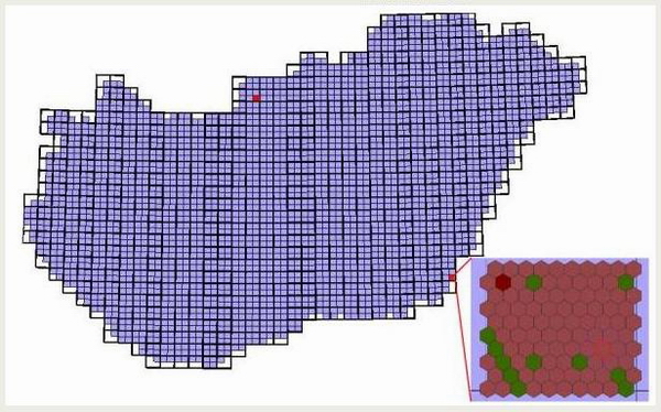
For the MÉTA survey a systematic grid of hexagons of 35 hectares continuously covering the territory of the country has been created in GIS environment. The hexagons are the basic units of both the survey and the database.
The figure shows the 2,834 quadrants of Hungary and the ca. 100 hexagons per quadrant. The colouring of the hexagons indicates the categories for ecoregion.
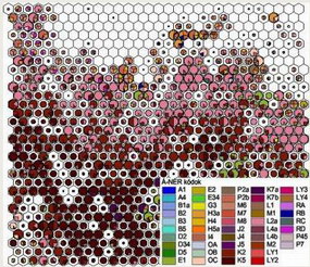
During the fieldwork, habitat list (according to the modified version of the Á-NÉR - National Habitat Classification System (mmÁ-NÉR)) for each hexagon with more than 25% cover of natural and semi-natural vegetation is documented. The habitat list is supplemented by 17 attributes on the actual state of the vegetation (see below for more details).
As a consequence of the need for collecting various kinds of up-to-date information on the state of the vegetation and the natural landscapes and the need for handling these data, a well-structured database is required to satisfy the requirements. For the MÉTA project an SQL database has been created with the capacity of storing and handling more than 1 million records of data. The data are to be visualised by ArcView.
Since there are more than 200 mappers involved in the vegetation survey, we had to ensure the more or less uniform approach to vegetation among them in order to ensure the consistency of the national database.
We used different tools to ensure the standardisation of the data collection and the quality of data (see MOLNÁR et al. 2005 for details). Before the field surveys, in order to reach the required uniform perception of vegetation, all mappers involved in the mapping (including the experts of botany as well) had to participate on a field training of 3 days. Conceptual ground for the field trainings was the idea of experiential learning. Two detailed guides were created for reaching more synoptic approach to vegetation. The Mapping Guide defines accurately the terms (several of them is never or scarcely used in Hungary – e.g. potential vegetation, regeneration potential), provides more detailed descriptions of the ones comprehended inconsistently in Hungary; gives advice for the planning of the survey route; determines the rules of the data-sheet completion, and lists the most common mistakes. The Habitat Guide includes the modified version of the Á-NÉR - National Habitat Classification System (mmÁ-NÉR) with descriptions of the particular types according to the following structure (1500-2000 words for each type): definition, site conditions, characteristic species, vegetation context, subtypes (list and short descriptions), types not belonging to the particular category (with the correct classification), the pattern on the satellite image characteristic of the certain type, characterization of naturalness and regeneration potential with examples.
The survey was carried out on three spatial levels, which are nested units of both the survey and the database: 1. quadrant, 2. hexagon, 3. habitat type inside the hexagon.
The figure shows the 2,834 quadrants of Hungary and the ca. 100 hexagons per quadrant. The colouring of the hexagons indicates the categories for ecoregion.
- The quadrant is the administrative unit. The quadrants are the quarters of the base units of the European Flora Survey. Their territory is approximately 35 km² and there are 2,834 quadrants in Hungary.
- Hexagon of 35 hectares is the basic unit of the survey and the database. 267,813 hexagons cover the whole country, and there are ca. 100 hexagons in a quadrant. The list of natural and semi-natural habitats is given for each hexagon. There are additional attributes collected for each hexagon (see below in details).
- In each hexagon a list of natural and semi-natural habitats is provided and completed with several attributes on the present status of the particular habitat. There are 2-4 habitat types in a hexagon on average.
What kind of data do we collect?
 The data is collected mainly by a single field survey of the hexagons in the quadrant. The mapper estimates the actual status on the spot. Hexagons with more than 25% natural or semi-natural vegetation are compulsory to survey and to be thoroughly documented on pre-printed, standardised datasheets. 20% of the data can be estimated based on satellite imaginary and forest management data. Land-cover data of hexagons that are not compulsory to survey are also documented on a different datasheet. Subtypes and other attributes for each habitat type found in the quadrant have to be documented too. The data collection fits the nested three spatial levels of the survey as follows:
On the habitat level:
- total extent of the habitat given as percent of area of the hexagon
- naturalness (in Hungary, the following system of naturalness is used 1: totally degraded state; 2: heavily degraded state; 3: moderately degraded state; 4: semi-natural state; 5: natural state (more precisely: the present state can be considered as natural ))
- landscape-ecological attributes (pattern, connectedness, isolation, neigbourhood)
- threats (improper water management, improper pasturing or mowing, melioration, encroachment of shrubs and trees, burning, afforestation with improper species, woodland patches managed homogeneously, improper selection of trees, logging trees at low age, inappropriate plantation, overkeepering of game, colonization of invasive species, building-up and construction, gardening, mining, establishment of a pond, trampling, pollution, rubbish, commercial collection of plants)
On the hexagon level:
- list of habitats
- extent of oldfields (abandoned more than 3 years ago) and invasive alien species as percent of the area of the hexagon
- potential vegetation
- present land use in case of grasslands (mowing, pasturing, the lack of management)
- category for ecoregion based on the actual naturalness and regeneration potential of the landscape (5 categories: 1. region with high value of naturalness, and with little or no potential for regeneration, 2. region with high value of naturalness that has the potential to regenerate, 3. region with mean value of naturalness, but with the potential of regeneration, 4. region with mean value of naturalness, lacking the potential of regeneration, 5. degraded, depreciated region)
On the quadrant level:
- subtypes of the habitat categories present in the quadrant
- the invasive alien species threatening the particular habitat type and the degree of invasion
- connectedness landscape level
Objectives | Methodology | What is database for? | References | Contact us | Supporters
WHAT ARE WE GOING TO USE THE DATABASE FOR?
Covering the whole country and containing quantitative and standardized data, the Actual Landscape Ecological Habitat Database (MÉTA) will serve as a suitable basis for maps, several kinds of analyses, scenarios, model-construction on both country and regional levels not only for scientific use but for strategic planning, water and forest management, agro-environmental policy and education. Let us give a few examples:
Basic ecological research:
- compiling the Map of Natural Vegetation Heritage of Hungary
- analysis of particular vegetation types
- ecological and vegetation analysis of particular regions
- landscape ecological modelling
Applied ecology and strategic planning:
- analysis for more successful nature protection (e. g. estimation of effectiveness of ecological networks)
- analysis of the potential impacts of a nature protection act
- the effects of water management on the vegetation of a particular area
- as an input vegetation layer for the analysis of the potential effects of climate change
- county-scale evaluation of road system developments on the natural vegetation
- for the identification of potential target objects of agro-environmental subsidies.
Environmental education:
- getting knowledge on the actual vegetation heritage of the country (what, where, what does it look like)
- local and regional educational materials for schools
- book chapters, atlases, maps, analysis, statistics in books used in primary and secondary schools.
Objectives | Methodology | What is database for? | References | Contact us | Supporters
REFERENCES
Zs. Molnár, S. Bartha, T. Seregélyes, E. Illyés, Z. Botta-Dukát, G. Tímár, F. Horváth, A. Révész, A. Kun, J. Bölöni, M. Biró, L. Bodonczi, Á. J. Deák, P. Fogarasi, A. Horváth, I. Isépy, L. Karas, F. Kecskés, Cs. Molnár, A. Ortmann-né Ajkai & Sz. Rév (2007): A grid-based, satellite-image supported multi-attributed vegetation mapping method (MÉTA), Folia Geobotanica 42: 225–247.
Objectives | Methodology | What is database for? | References | Contact us | Supporters
CONTACT US
Functional Ecology Department, Institute of Ecology and Botany, Centre for Ecological Research, Hungarian Academy of Sciences, Alkotmány u. 2-4., 2163 Vácrátót, Hungary
The leader of the MÉTA Programme: Zsolt Molnár
tel: +36 28 360 122/160, e-mail: molnar.zsolt@ecolres.hu
Advisory board of MÉTA: Zsolt Molnár, Ferenc Horváth, János Bölöni, András Horváth
e-mail: meta-kuratorium@list.ecolres.hu
Informatics team of MÉTA: Ferenc Horváth
tel: +36 28 360 122/157, e-mail: horvath.ferenc@ecolres.hu
Objectives | Methodology | What is database for? | References | Contact us | Supporters
SUPPORTERS
Our research was supported by
- the project "Surveying and comparative analysis of Hungary's natural vegetation heritage, 2002-2005" funded by Széchenyi Plan (NKFP 3B/0050)
- the project "Interaction of natural & artificial ecological systems: landscape ecology studies of biodiversity and ecosystem functions in the Hungarian Great Plain, 2002-2008" funded by the Jedlik Ányos Program (NKFP6-0013/2005)
- The Ministry of Environment and Water, as the beneficiary and potentially the main user of
our results by providing supporting statements. - The GSDI Association announced grants awarded for 2005 to fifteen organizations around the globe . The grants are aimed at assisting member organizations (IEB HAS of HUNAGI) in building key components of emerging Spatial Data Infrastructure.